


Le Pradet _ Plage de la Garonne - La Colle Noire

soca
User
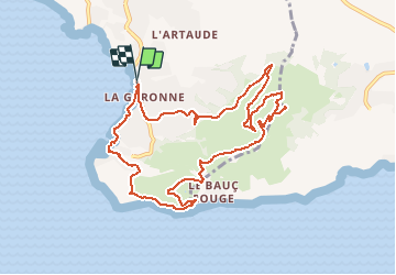

Length
11.4 km

Max alt
285 m

Uphill gradient
380 m
Km-Effort
16.5 km

Min alt
1 m

Downhill gradient
380 m
Boucle
Yes
Creation date :
2021-01-30 16:48:44.319
Updated on :
2021-01-30 16:50:19.952
4h00
Difficulty : Easy

FREE GPS app for hiking
 SityTrail
IGN / Geographical institutes
SityTrail Plus
The world is yours!
About
Trail Walking of 11.4 km to be discovered at Provence-Alpes-Côte d'Azur, Var, Le Pradet. This trail is proposed by soca.
Positioning
Country:
France
Region :
Provence-Alpes-Côte d'Azur
Department/Province :
Var
Municipality :
Le Pradet
Location:
Unknown
Start:(Dec)
Start:(UTM)
257858 ; 4775414 (32T) N.
Comments